Saint-Martial in the Southern Cevennes (Gard)
The unique heritage of the Southern Cevennes region comprises its history, its natural milieu, its man-made landscape and the way of life that has evolved in these settings. These elements are all found in the territory of Saint-Martial which boasts a number of singular features that are particularly worth of interest. The natural landscape with its man-made modifications, the way of life, the history of the people and their places form the foundations on which the Cevenol identity and the Saint-Martialaise identity has been built .The objective of the “Val d’Elbès Association, is to idntify, promote and celebrate all these aspects of the heritage of the commune of Saint Martial.
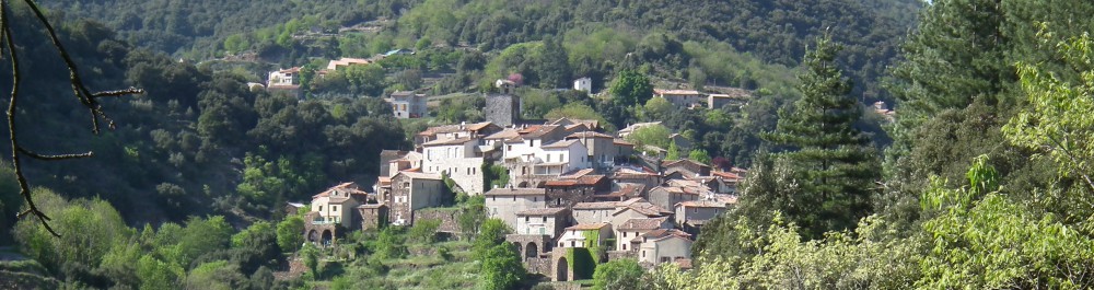
Saint Martial is a “perched village” built on a rocky outcrop situated at a distance of around 15 kilometres from the town of Ganges. It is a naturally defensive site bound by the waters of the Elbès to the east and the Hoste to the west. The commune spans a geologically mixed zone where the granite of Mont Liron (1133 metres) to the north juxtaposes the shale of the Rieutord Valley to the south. The village itself sits at a height of 464 metres with hamlets and farm houses scattered around the surrounding hills and valleys. The farmhouses cling improbably to the precipitous slopes which themselves have been fashioned into terraces that are as breathtaking for their scale and the way that they integrate into the landscape as they are for their charm.
More than ten centuries of history
The indications of human habitation around Saint-Martial date back to the Neolithic era. Numerous standing stones (menhirs or pierres levées) mark the intersection of the ancient routes and footpaths which traverse the saddles of the surrounding mountains. However it was not until the Middle Ages that the village of Saint-Martial was founded with the construction of a “Castrum”, a fortified edifice consisting of a chateau, a church and a town which acquired the name of “El castel de San Marsal”. In the tenth century, the village and the surrounding country belonged to the House of Anduze, a noble family, a member of which bequeathed his entitlements to the diocese of Nimes. The village was then used as a summer residence by consecutive bishops of Nimes and became an established base for the clerical hierarchy.
During the dreadful era of the wars of religion in the 16th and 17th centuries, the Valley of the Rieutord remained a bastion of Catholicism despite the sweeping incursions of the Huguenots elsewhere in the Cevennes. Together with the residents of the two neighboring communes, (Notre–Dame de la Rouvière and Saint André de Majencoules) the residents of Saint-Martial constituted a Catholic enclave in the Protestant territory, which became known as “the White Cevennes” or “Les Terres Blanches”. Loyal to the King and to the Church of Rome the residents of this region were opposed to the ideas of the Revolution. This spirit of resistance also prevailed under the Consulate after the fall of the Directory in 1799 and under the Empire.
Until the middle of the 19th century, Saint Martial was essentially economically self-sufficient deriving its livelihood from locally produced food crops, notably chestnuts, together with ovine meat and milk production.
In the nineteenth century and through to the beginning of the twentieth Century the silk (and silk worm) industry emerged as a major economic force: silk mills were established at Sumène, Mazel and Valleraugue and there was also a small mill in Saint-Martial. The women played a key role in ensuring that the eggs of the silk moths were kept warm, hatching them in the folds of their garments and then feeding the voracious worms. At this time, most of the households added an extra storey to create a loft area for raising silk worms. However, the rearing of silk worms proved to be highly demanding and became progressively less viable due to the vulnerability of the silk worms to a host of maladies. Hence, the activity ceased after 1945. Nevertheless, there was still sufficient economic and communal activity and trade in Saint Martial to support a population approaching 900 inhabitants at the beginning of the 20th century.
Today, Saint-Martial’s economy is based on onion growing and tourism.
A Landscape fashioned by Man
In the early Middle Ages the peasants practiced slash and burn agriculture on small tracts of land, mainly growing grains for bread making. The terraces constructed across the slopes from the 12th century onwards, were thus used primarily for growing cereals. At the beginning of the 14th century this method of cultivation was expanded to allow the additional cultivation of chestnut trees, grapevines and olive groves in the Southern Cevennes. The population growth in the 16th century led to the further expansion of terracing, to the introduction of water reticulation and to the expansion of the chestnut orchards. In the middle of the 18th century the extent of the terraced areas was increased again to accommodate the cultivation of mulberry trees. These areas of extensive terracing, which peaked between 1750 and 1850, are the most characteristic identifying feature of the Cevenol landscape.
While man may have modified the landscape, the dwellings that were built were integrated within and adapted to the environment. The mountainous relief of the Commune of Saint-Martial, composed of shale and granite, its climate, its agro-pastoral traditions and it’s proximity to the plains of the Languedoc have all influenced the architectural heritage.
The farmhouses in the commune tend to be long, narrow and tall. They are usually built at right angles to the contours of the landscape, although sometimes they are parallel to the contours, depending on the size and availability of a flat building site. The construction materials (shale stone or granite and chestnut timber) are drawn from the immediate vicinity and only minimally transformed. Indeed many houses have natural rock foundations or integrate natural rock walls in their construction
The siting of buildings depends on the availability of water, the suitability of the land for arable terracing and the solar orientation.
The relatively impermeable shale and granite soils feature numerous springs whose modest water flows are captured in small dams (known as gourges) to provide water for both irrigation and domestic needs. The Mediterranean climate typically generates torrential rain in spring and autumn. However, in summer, the watercourses and springs often dwindle or run dry necessitating active water management. Given the steep terrain, water management works have been constructed to protect the arable land from erosion, regulate the water flow in floods and channel water to the cultivated areas.
A Village of Fine Architecture
Saint-Martial is situated at a height of 464 metres above sea level. Its foundations date back to the feudal period. The first documented mention of the village, under the title Castrum Sancti Martialis, was in 1156. It was a fortified site with the open valley surrounding it providing the site with natural protection.
The village is built on a rocky promontory of solid shale. The dwellings are grouped in descending concentric layers around the summit (known as a village en circulade ) crowned by the “castrum”. The streets are laid out in a circular plan following the natural contours. These are intersected by perpendicular passageways and flights of stairs which scale the steep slopes of the rock promontory.
The houses are tightly clustered and are designed to shelter animals as well as their human occupants. In the 18th century during the boom in silk production, most of them had an extra floor added to create a loft space for raising silk worms.
The church is a fine example of the Romanesque style with a Latin Cross floor plan. It juxtaposed the Chateau of the “Castrum” and probably served as its chapel. It has been modified many times over the centuries. The oldest part is the nave, which dates from the 11th and 12th centuries. It was fortified during the wars of religion hence the form of its clock tower which also served as a fortified watch tower.
The numerous centuries-old farms (mas) and hamlets contain many relics of the self-sufficient subsistence style economy of days gone by.
Mas is an Occitan word, coming from the Latin verb maneo ( to remain, stay the night, reside) from which the noun mansus is derived. This is also the root of the French noun maison. A mas is typically located in the centre of the terraces. The chestnut groves are located directly above it. Above the chestnut groves, the stony, infertile areas, forested with holm oaks are grazed by sheep and goats. Water from the springs is captured in reservoirs known as gourgues, which are sheltered by a stone vault to prevent evaporation in summer. These reservoirs are integrated into the walls of the terraces and are used to irrigate crops. The mas was designed to provide for a self-sufficient existence and thus provided all the resources necessary to support the needs of its inhabitants. It would include specialized features such as a clède a small self contained building which is used to dry the chestnuts, a bergerie to house the sheep in winter, a magnanerie which houses the silk worms under the rafters, a four à pain (the bread oven), la soue à cochons (the pig pen), shelters for poultry and rabbits, a wine press and a short distance away, le rucher (bee hive).
Preserving the natural environment
Across the undulating landscape the typical vegetation of the Southern Cevennes is dominated by the emblematic tree of the Cevennes, the arbre à pain (bread tree) so called because it provided a food staple for generations of Cevenol people. It would originally have been indigenous to the silicious, granite and shale soils of the south of the Massif Central in the tertiary era. Its cultivation in a more intensive fashion was initiated by the Benedictine monks who settled in the region in the Middle Ages.
The strong population growth in the 16th century resulted in a dramatic expansion in the cultivation of this species in the Cevennes. The chestnut became the primary source of food, being consumed grilled, fresh or dried in the clèdes and ground into flour. The blanchettes (kernels) have a long shelf life and were also used to feed animals. The leaves were fed to sheep and goats, and the timber was used for building and woodcraft. This resource continued to be relied upon until the 20th century when it succumbed to the ink disease fungus (from 1860) and subsequently to bark canker or chestnut blight (around 1956).
The chestnut groves which survive today create an environment which is extremely rich in fauna, providing the animals with shelter and food. The thick carpet of leaves which collects in autumn composts down to a sweet humus which encourages the proliferation of numerous invertebrates including earth worms, creating a feast for moles in spring and for wild boar throughout the year. There is now little interest in harvesting the actual chestnut crop, with most of the crop providing forage for a number of species including rodents, (field mice, voles and squirrels) carnivores (foxes and weasels) and hoofed animals (sheep but also roe deer and occasionally red deer) which consume this life-saving manna in winter.
The holm oaks covering the rest of the slopes are intermingled with a variety of other vegetation such as white cistus, heather, wild broom, Irish strawberry trees (arbutus), fig trees and so forth. Numerous species of butterflies and birds also thrive in these protected expanses.
It should also be remembered that the dense scrub formed by the local vegetation ( le maquis) also served as a refuge for the Resistance throughout many periods in history.
Walks for Visiting and Exploring Saint Martial and its Environs
Four circular walks around the village, each focusing on a particular theme have been created to encourage visitors to acquaint themselves with the various aspects of Saint Martial’s heritage and to deepen their knowledge on-site. They are designed to provide an introduction to both the natural environment and the architectural heritage. The walks are quite steep in parts but pose no particular difficulties.
Balade Schiste : The “Shale stone” Landscape
Distance : approximately 8 km
Time required : Between 3 and 5 hours
This walk takes you through the chestnut groves in a southerly direction to follow a route that leads you along the mountain ridges.
Balade Granite : The “Granite” Landscape
Distance : Around 6km
Time required : Around 3 hours, with the possibility of an additional detour of around 1.2 km taking roughly 30 minutes.
This walk explores the granite territory and, if you take the additional detour this takes you across the highest parts of the commune where the natural environment is composed of forests and open prairies.
Balade Habitat Cevenol :“Cevenol Habitations”
Distance : Around 8.5km
Time required : Between 4 and 5 hours depending on your walking speed and the number of stops made along the way.
This walk allows the visitor to discover the different ways of life that have evolved over the years: the communal life of the village, the hamlet with its mutual support systems and the self-sufficient life style of the mas.
Decouverte du Village : “Discovering the Village”
Time required : around 1.5 hours
This walk through the village itself allows you to view the characteristic architecture of the houses with their vaults and arches, the steep narrow streets and footways known as calades, the circular layout of the village, its remarkable Romanesque church and the sweeping views over the surrounding slopes and valleys and their terraces, known locally as serres, faïsses or traversiers .